Pages

Trek to Nakhind

Difficulty Rating : 3/5
Height : 2300 ft
Location: Vangani, Maharashtra, INDIA

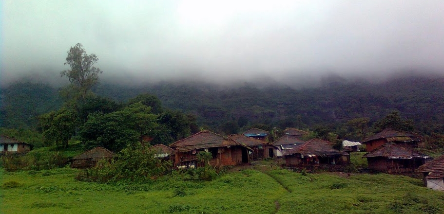
The march to the base

Nakhind (नाखिंड) is known for its naturally formed 'gap' in the hill, as if a hole has been punched through it. In marathi, it is called nedha (नेढ)  or a needle-hole.There are very few forts having this kind of peculiar geographic formation like Rajgad, Madangad....

How to reach:
Go to Vangani station (central railway). Take the back-side exit (towards CST). Take the small road and reach highway. You can now see another road on the opposite side leading to the village. Cross the highway and keep walking along the straight road. After reaching the village anyone can guide you from there. 

Nakhind trek is much similar to Chanderi trek with long approach route to the base and then the actual trekking trail. Every monsoon sees the formation of a waterfall, which is a perfect hangout for picnickers and those who don't like trekking.

The dirt track to the base is surrounded by paddy fields and fascinating landscapes. 


A 3-4 km walk brought us to a small village.The trek starts from that point onwards.We never got a chance to see the hill from the base, it was engulfed in fog all the time, and the rains made sure the this situation continued.


On our way we came across many streams and rivulets. Don't try to protect your shoes from getting wet, as anyway they are going to get more than wet. What awaited us was a wide, knee deep water channel .It was fun crossing this brook ,slipping on small stones and falling in the water; and getting out of water, fully soaking wet, and same time for  the wind to blow hard enough to make u shiver !!


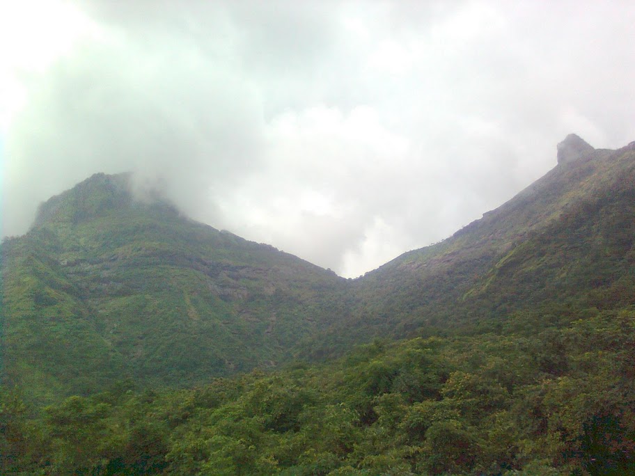
U'll get to see another tiny brook, which transforms into a mini waterfall every monsoon .It was so very tempting that every one had enough fun under it, and that actually help to restore our energy to climb the final steep slope. This slope will directly take u to the top. After reaching the top one needs to traverse along the mountain ridge to reach the final destination. Walking on this ridge, with deep valley on both sides and the trail lost in fog was a thrilling experience.


The trail ends near a huge pinnacle like rock. From this rock a left turn and a few steps took us to this alluring  form of nature.

A hole right thru mountain!!
Completely 'aarpaar'
Actually the space at the top is very less and it can accommodate some 8-9 people at a time; and the same reason being I couldn't capture the whole of the 'gaping' in my NOKIA 2700. The fog completely restricted the visibility, otherwise we could have got a stunning sight of forts of Matheran range.


Nakhind is perfect for one-day trekking destination. I would recommend taking a guide with you if you are not confident with the route. This visit was planned with my father (Dilip Phal) and his friends.

Trek to Chanderi fort (Vangani)

Difficulty Rating: Tough
Height: 2343 ft (714 m)
Per head cost: 250 INR (From Dadar to Dadar, incl. lunch, snacks)
Location: Vangani, Maharashtra. INDIA
Date: July 2011


Chanderi (चांदेरी) trek was my second monsoon trek in my first year of Engineering.

How to reach Chanderi fort:

To reach Chanderi fort base village, we need to cover a long distance from Vangni station. Exit Vangani station from back side (towards CST side). Walk the small road from the station crossing that meets the Neral-Badlapur highway. Take an auto to reach Kasgaon (कासगाव) junction in the direction of Kalyan/Badlapur. Kasgaon is roughly 5 km and will take 45 minutes by walking, or 10 minutes in an Auto/car. Take a left turn from the Kasgaon junction, to reach Chinchavali village.

Kasgaon to Chinchavali is another 45 minutes walk (4 km) and 15-20 minutes by Auto/car. (Remember, I am writing in July 2011. Somethings might change, but the distances will remain same). So in short, the trek route follow via Chinchavli village, which is at a distance of about 7-8 km from Vangani station.

We made our way from newly built farm-houses, empty plots, a small stream (it was almost a size of river) and tons of mud, and we arrived at a small school. That is the starting point of the trek.

This trek will be more like a trudge for first timers. If you are a frequent trekker and thorough with the approach route, it'll take hardly an hour or two. Otherwise 3 hrs would be sufficient (from base). The area of the foothills is really fascinating during monsoons. On your way don't miss these-


A short 20 min walk will take you to a plateau (looks more like a hunting ground) where you get an elegant view of Chanderi fort on the left and Mahismaal on the right. The col in the middle separates the two forts.


This place was the first rest point for our group. The real trekking adventure is yet to begin. The trail follows through the hillocks and shrubs, right to the col. Chanderi is known for its getting lost in the jungle. Not finding the trail is kind of expected phenomenon. And if u take a wrong turn, you will either find yourself amidst huge boulders or into a water stream !! But no worries. This is how you become a mountaineer. There are many waterfalls (small to mid-sized) and the route is very slippery during rainy season. After the col, the route is filled with scree. Many local organizations have tried to mark the route but some or the other marker can be seen missing. The best way would be to ask a villager to follow you. Atleast you wont waste time searching for right route.
Pro-tip: If you think you are lost, then search for arrow marks on the boulders or the tree trunks. There are also saffron bands or some markings on the trees (not always) that can be helpful.

               
After all this tedious but equally refreshing journey, we finally reached the top. Once you see the cave, stop there. That is the maximum limit you can go (atleast during the monsoon). This cave lies below a huge square massif. There is an old idol kept inside the cave. But we were so famished that we decided to have our lunch first आधी पोटोबा, मग विठोबाThere isn't much for sightseeing at the top. But if lucky, and with good visibility, you can get a magnificent view of Peb, Matheran, Prabalgad, Irshalgad in Panvel region. With even better visibility, Gorakhgad, Siddhagad and Bhimashankar can be seen. Avoid going beyond the huge rocks and boulders as its very risky during monsoons. The 300 ft. pinnacle is one of the favorite destination for many climbers. Top of the fort can be reached from the back. We didn't climb the pinnacle as it was slippery. People visit Chanderi throughout the year. A small statue of Ch. Shivaji Maharaj can be seen at the top. 


The descend wasn't that tough, but the route was a bit slippery because of the rains. The waterfalls couldn't be missed. We reached the village @ 7.00 pm. where we met a guy who turned out to be a milk-van driver, and we got a free lift to Vangni station. All-in-all, Chanderi trek turned out to be one of my adventurous 1-Day trek. Had been there with my father (Dilip Phal) and his friends.

Some more information:
Height of Chanderi fort is 2343 ft. Chanderi fort is considered a tough fort (not as tough as Alang-Madan-Kulang). Accidents due to stones falling from the top are quite known here. Always be alert when near waterfalls as the water tends to move a lot of stones along the way. Remnants of 'fort' can be seen in form of broken wall (तटबंदी). Otherwise, the view from the top is, as always, amazing!
 
Update January 2021:
The GPS route is available and can be accessed by clicking here. For summer trek to Chanderi fort click here.

Our most recent adventure...

Chanderi fort trekking

Date: January 2021 Trek type: Jungle fortress, 714 m Difficulty: Walking on moderate to difficult terrain (no rock-climbing) Availability of...